Tourist / Visitor Attractions in the Rhins, Scotland
All visitor attractions in the area are automatically added to the directory, free of charge. If you know of a visitor attraction which is not listed here then please let us know by using the contact form. Thank you.
- All (37)
- Aquariums (1)
- Beaches & Rocky Shores (16)
- Castles & Historic Sites (15)
- Cinemas & Theatres (1)
- Gardens (6)
- Leisure Centres (1)
- Lochs & Reservoirs (6)
- Museums & Visitor Centres (3)
- Parks (1)
- Putting Greens (1)
- Walks (12)
- Woodlands & Nature Reserves (4)
Results 1 to 10 of a total 12 for Walks:

Aldouran Glen (Woodlands & Nature Reserves, Walks)
- Address: Leswalt, 54.928808, -5.097111. [location map]
- Website: http://www.leswaltwetlandgarden.org.uk
- Admission: Free
Aldouran Glen consists of a wetland area with ponds, a boardwalk over marshland and a bird hide as well as the woodland owned by the Woodland Trust. There is a circular walk that can be completed through the woodland up the hill with magnificent views on the way down to village.
Near to: Stranraer,
Leswalt,
Kirkcolm.
Ardwell Bay (Castles & Historic Sites, Beaches & Rocky Shores, Walks)
- Address: Ardwell, 54.761912, -5.000081. [location map]
- Admission: Free.
On the opposite side of the Rhins to Ardwell itself is this hidden gem of a bay - sandy with rock pools. There is also a walk to Doon Broch - an early fort built between 100 BC and 200 AD.
Near to: Ardwell,
Sandhead,
Port Logan.
Galdenoch Castle & Salt Pans Bay (Castles & Historic Sites, Beaches & Rocky Shores, Walks)
- Address: Leswalt, 54.922485, -5.163926. [location map]
- Admission: Free.
If you have an OS map of the area will notice a 'P' sign right by the 16th century Galdenoch Castle - if you park here you can have a look at the ruined tower and then walk down to the shore. On your way to Salt Pans Bay you will pass a small loch which often has geese and ducks on. You will also pass through the breeding ground of Red Deer so is probably best avoided during the rutting season. Salt Pans itself is an SSSI protected sandy bay overlooked by an Iron Age fort and towering rocks.
Near to: Leswalt.
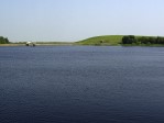
Knockquhassan Reservoir (Lochs & Reservoirs, Walks)
- Address: Stranraer, 54.890291, -5.079892. [location map]
- Admission: Free.
Reservoir with easy access from Southern Upland Way. Walk either way on the SUW from the reservoir and it's not long before you are rewarded with magnificent views. The reservoir supports fish and attracts many different species of birds.
Near to: Stranraer,
Portpatrick,
Leswalt.

Luce Sands (Beaches & Rocky Shores, Walks)
- Address: Sandhead, 54.806012, -4.961388. [location map]
- Admission: Free.
Luce Sands is a gloriously long stretch of sandy beaches. The sands are most accessible from Sandhead where you can walk along the shore for 3 miles at low tide. There is a large parking area with picnic tables.
Near to: Ardwell,
Sandhead,
Stoneykirk.
Mull of Galloway Visitor Centre (Museums & Visitor Centres, Beaches & Rocky Shores, Woodlands & Nature Reserves, Walks)
- Address: Mull of Galloway, Drummore, 54.635224, -4.860379. [location map]
- Telephone: 01776 830682
- Website: http://www.mull-of-galloway.co.uk
- Admission: Free.
Information about the RSPB reserve and it's wild inhabitants. Live camera link to breeding birds on sea cliffs.
Near to: Drummore.
Penwhirn Reservoir (Lochs & Reservoirs, Walks)
- Address: Cairnryan, 54.983549, -4.925010. [location map]
- Admission: Free.
A large reservoir with views over open land and various footpaths surrounding it.
Near to: Cairnryan.
Port Mora & Port Kale (Beaches & Rocky Shores, Walks)
- Address: Portpatrick, 54.842671, -5.120323. [location map]
- Admission: Free.
Follow the Southern Upland way from Portpatrick and you will come across two bays. The first, Port Mora is a sandy beach with interesting caves. The second, Port Kale is a pebbly, rocky beach that meets up with Dunskey Glen.
Near to: Portpatrick.
Southern Upland Way (Walks)
- Address: Portpatrick, 54.842700, -5.120209. [location map]
- Website: http://www.southernuplandway.gov.uk
- Admission: Free.
The Southern Upland way is a long distance (212 miles!) path that starts at the North end of Portpatrick and takes you all the way to Cockburnspath in the Borders on the East.
Near to: Stranraer,
Portpatrick,
Leswalt,
Castle Kennedy,
Dunragit,
Stoneykirk.
Stranraer Town Trail (Castles & Historic Sites, Walks)
- Address: Stranraer, 54.906168, -5.031251. [location map]
- Website: http://www.stranraer.org
- Admission: Free.
You can pick up a leaflet for this walk around Stranraer from the Tourist Information centre. The trail takes you round some of Stranraer's most historic and interesting buildings. Look out for the blue information plaques on walls along the way.
Near to: Stranraer,
Leswalt,
Castle Kennedy.